

Want to be the first to see weather news? Sign up for our weekly email weather newsletter, featuring weather journalist Kevin Myatt.
A decade plus one year may have softened the buzz, but the word “derecho” still carries a sting.
Before June 29, 2012, the word “derecho” – properly pronounced “day-RAY-cho,” though more often said “duh-RAY-cho” – didn’t cross the lips or minds of many Virginians. In the years afterward, the quietest whisper of it or most remote anticipation of possibly having one has often evoked dread and fear.
In the summers since tree-breaking, power-crashing winds roared across almost all of Southwest and Southside Virginia on the hottest day in a generation, every hint of a squall line moving in from the west or north or northwest has brought on numerous inquiries: “Is this a derecho?”
Most often, it wasn’t. A couple or three times, it might have been one, marginally. But it has never been like that one 11 years ago Thursday.
* Smoke from Canadian wildfires has returned to Southwest and Southside Virginia on northwest wind flow, choking visibility and reducing air quality. Click here to read a previous Cardinal Weather column about the smoke’s origin and its first arrival earlier this month.
“Derecho” isn’t, as some have imagined, a word created out of thin air in recent times.
It was coined in 1888 by University of Iowa physics professor Gustavus Hinrichs to differentiate a straight-line windstorm – “derecho” is Spanish for “straight ahead” – from the cyclonic rotating storms we call tornadoes. Meteorologists Robert Johns and William Hirt revived the term in 1987 with research documenting several of these long-lived windstorms over the central and eastern U.S.
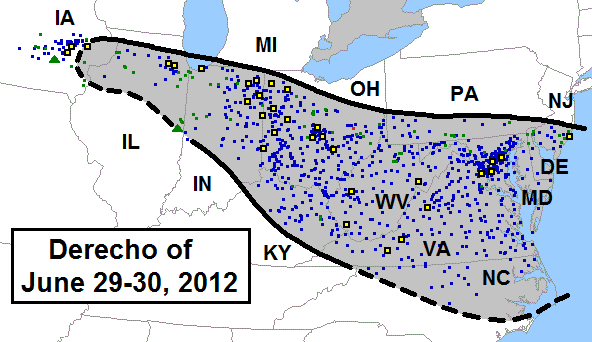
“Long-lived” is important. A derecho isn’t just a thunderstorm with damaging winds. It isn’t a cluster of storms that carries gusty winds across a few counties. Though there is some variance in definitions, it is generally recognized as a continuous line of storms (typically forming a bow-shaped echo on radar) that carries severe winds (58 mph gusts or greater) over most of a track at least 240 miles in length and 60 miles in width.
There is no such thing as a “localized derecho.” A thunderstorm with one big gust can knock a tree on a transformer and cut off your power, but that’s not a derecho.
A derecho is propelled by winds that generally blow in the same direction from the surface to aloft, though there are sometimes some more converging or twisting winds on its northern and southern flanks. Hot, humid air in front of the line continually feeds its updrafts, while downdrafts produce the damaging wind that fan out under and in front of it. The cooler downdrafts form a cold pool behind the squall line that can propel a derecho forward at amazing speeds, 60 to 100 mph, further increasing its winds.

On June 29, 2012, a storm cluster that formed in the early afternoon near Chicago had undisturbed, extremely hot air in front of it all the way to the Atlantic coast. The afternoon high of 104 at Roanoke was the hottest temperature since 1983; the 103 high at Lynchburg the hottest temperature since 1954. Danville and South Boston also reached 104; the co-op station at the John H. Kerr Dam in Mecklenburg County soared to 107.
When the bowing storm line crossed over from West Virginia in early evening, having already left hundreds of thousands without power across the Midwest and Ohio Valley and into the Appalachians, the storms were actually in a weakening phase, but the gust front in front of the derecho had so much momentum it kept going unabated even before storms began re-strengthening east of the mountains.
An 81 mph gust was clocked at the Roanoke-Blacksburg Regional Airport near 9 p.m., and widespread gusts of 50-80 mph were common across the region with perhaps a few spots going to near 90 mph.
Very little rain fell in most locations as the derecho passed, some places even experiencing wind-blown dust more like a western U.S. dry thunderstorm. A few places got sideways heavy rain, but it didn’t last long. Flooding wasn’t the issue with the June 29, 2012, derecho.
The derecho took less than 3 hours to cross our region, with numerous reports of tree and power line damage in nearly every county, and some structural damage. The southwestern tip of the state was least affected, but those areas would get additional windy storm clusters in days ahead, which also featured many 90s-100s highs each day until July 9 as power was slowly restored for many thousands who lost it.
The 2012 derecho wasn’t a one-off kind of storm.
In fact, another derecho blasted across our region the following year on June 13, 2013. It wasn’t quite as damaging on the whole, but it was worse in some spots – my southern Roanoke County neighborhood, for instance, had almost no damage in 2012 but many trees down and temporarily lost power in 2013.
A windy squall line that would have likely qualified as a derecho caused much damage and power outages across our region in June 1993. Lynchburg was particularly hard hit.
A 1954 weather pattern nearly identical to that of June 2012 produced a large derecho that barely scraped our region to the north, hammering the Washington, D.C. area.

Climatological research reveals that Southwest and Southside Virginia can expect a derecho about once very four years – once every two years in the southwest tip of the state.
So it’s only a matter of time until we experience another derecho, though it may or may not be like that derecho was.

Even the June 29, 2012, derecho was not nearly as bad as it can get. No wind gusts over 100 mph were recorded along its entire path from Illinois to the ocean. Meanwhile, gusts of 126 mph were measured and 140 mph estimated in Iowa with the August 10, 2020, derecho that swept from Nebraska to Indiana.
We shouldn’t get overly caught up in the single word “derecho,” as squall lines and thunderstorm clusters that fall well short of the derecho definition for length of damage can cause plenty of mayhem.

Severe storms
While there has been nothing resembling a derecho, Monday did bring a spate of severe storms that dropped some big hail and caused some wind damage generally along and east of the U.S. 29 corridor, though also some in the Lexington area.
A cold front pushing into warmer, stickier air than we’ve seen most of June triggered the storms, with cooler, drier overspreading aloft in a setup more similar to Plains-type severe weather outbreaks than what we normally see in the East. Discrete storms with rotating updrafts developed, though high bases and somewhat lesser atmospheric shear than earlier expected kept any tornado threat in check.
Sunlit cumulonimbus clouds provided some interesting skyscapes for those not getting pounded underneath them.

90-degree heat
The run without a 90-degree high did not quite reach July at Roanoke, which recorded its first 90-degree temperature of 2023 on Sunday, June 25, tied for fifth latest first 90-degree high on record, and the latest in 20 years.
Lynchburg and Danville have still yet to reach 90, and may take that run without a 90-degree day into July for only the sixth and second times, respectively.
There continues to be no sign of a scorching heat wave on the horizon for our region, though we may be close enough to an expanding heat-dome high-pressure system over the south-central states to see a few more summerlike days as we move into July.
Short periods of hotter afternoons in the 80s to lower 90s will likely be interrupted by cold fronts and possibly storm clusters from the northwest.
There is some possibility a “ring of fire” pattern will develop with high pressure centered to our west, and rounds of storms circling it, sliding into our region from time to time.
And that gets us back to at least the outside chance that one of those storm clusters could be a derecho … but also, again, how we shouldn’t fixate on that word.
Journalist Kevin Myatt has been writing about weather for 19 years. His weekly column is sponsored by Oakey’s, a family-run, locally-owned funeral home with locations throughout the Roanoke Valley.

