

Land doesn’t vote, people do.
That’s a point that has to get emphasized every time there’s one of those red-and-blue election maps that shows a geographically small slice of Virginia (or the United States) outvoting everything. That’s simply where the people are.
Accordingly, simply looking at the Democrats’ proposed congressional redistricting maps — subject to a Virginia Supreme Court ruling and maybe an April 21 referendum after that — doesn’t necessarily give a good picture of where the population in each district is.
The proposed 7th District, now dubbed “the lobster district” because of its crustacean-like shape, encompasses a lot of rural territory through the Piedmont, the Shenandoah Valley and even parts of Southside, but its population base is inside the Beltway. It looks like a rural district but, population-wise, is very much a suburban one, which will come as quite a shock to voters in far-off Deerfield in Augusta County.
The number-crunchers at the Virginia Public Access Project have now done their work and computed how much of each district is in which locality. This lets us analyze where the political “weight” of each district lies. Note that their numbers are based on “voting age population,” which is not the same as actual voters (registration percentages and turnout percentages vary) but is still a good guide — so here’s a district-by-district assessment. Also note that the numbers get more interesting the higher the number of the congressional district.

1st District: Vindman’s district becomes more Northern Virginia-focused

Incumbent: Eugene Vindman (D)
Vindman currently represents the 7th District, a rectangular district, but the new map has him in the 1st, an elongated district that would stretch south to King William County. This district becomes more suburban.
Vindman’s old district had 52.33% of its population north of the Rappahannock River in Prince William County (32.01%) and Stafford County (20.32%).
Vindman’s new district would have 62.38% of its population north of the Rappahannock. This comes through picking up part of Fairfax County, which would now become the biggest part of the district (24.20% to 23.02% for Prince William).
More importantly for Democrats, Vindman gets a somewhat safer seat. He won reelection by 2.64 percentage points two years ago; now he’s in a district with a +7.7 Democratic advantage.
2nd District: With a few tweaks, Kiggans’ Hampton Roads district becomes more Democratic

Incumbent: Jen Kiggans (R)
This district originally didn’t change much at all, likely because mapmakers were hesitant to touch the 3rd District next door, which is represented by Democrat Bobby Scott. Last week, though, legislators swapped some precincts in Chesapeake and Virginia Beach to bump up the Democratic share of the vote.
The other notable change is that the 2nd loses the portion of Southampton County it once had, but that was only 1.37% part of the district anyway.
Virginia Beach had constituted 56.69% of the district; now it’s up to 58.90%.
Chesapeake bumps up from 16.56% to 17.44%.
Politically, this is now a little bluer than before. Kiggans won last time by 3.84 percentage points; now this is a +4.8 Democratic district.
3rd District: Still a solid Democratic district anchored in Hampton Roads

Incumbent: Bobby Scott (D)
This district picks up Poquoson, but that’s only 1.56% of the new district. Scott won this district last time by 40.11 percentage points; now this is rated a +26.8 Democratic district. Scott can afford to give up some Democratic voters to help the party in the 2nd District.
Let’s move on, nothing to see here.
4th District: McClellan loses a lot of metro Richmond, gains much of Southside

Incumbent: Jennifer McClellan (D)
Now we get into the more significant changes.
In the current 4th, the Richmond metro constitutes 74.10% of the voting age population. The proposed 4th is far less Richmond-centric; now just 39.53% of the district comes from parts of Richmond, Henrico County and Chesterfield County.
The new district would go east to pick up part of James City County and all of Williamsburg (between them, 10.88%), but then ranges west as far as Danville and Pittsylvania County (between them, 13.03%).
There’s no reason to believe that McClellan is vulnerable to a primary challenge, but she does lose much of her Richmond base, although overall, only 17.7% of the voting age population is new to her.
Less noticed: This district has gone from an urban one anchored in the Richmond metro to a predominantly rural one where Southside voters dominate. Congresswoman McClellan, welcome to Cardinal country!
McClellan won reelection by 34.99 percentage points; now her district is rated +16.1 Democratic. Politically, she’s sacrificed a big margin to help pad neighboring districts with Democratic voters.
5th District: This would now be a Richmond-based district with some Southside counties added on
Incumbent: None.
Republican John McGuire represents the current 5th, but the new map draws him into the 7th, aka, the lobster district.
While the map of the new 5th bears some superficial likeness to the current 5th — it brings in a lot of Southside counties — the political weight has shifted dramatically.
The current 5th is a Southside district with Charlottesville and Albemarle County (20.27%) added on. That’s why it’s so hard for a Democrat to win that district.
The new 5th would be a Richmond-based district: 77.96% of the voters would come from the Richmond metro (35.25% from Chesterfield County, 31.37% from Henrico County, 10.54% from Richmond, 0.80% from a tiny slice of Hanover County).
The next biggest share of voters would come from Campbell County (7.19%), but those rural voters are simply padding.
It’s almost unfair to compare the current 5th with the new one. McGuire won election by 14.99 percentage points; the new district is rated +8.7 Democratic.
True to its new political weight, the only candidate here now is Democrat Shannon Taylor from Henrico County.
6th District: This would become a ‘university district’ where Charlottesville, Lynchburg and Roanoke areas would have equal weight

Incumbent: None?
Don’t be confused. The current 6th is represented by Ben Cline, but the new map puts his Botetourt County home in the 9th and the Salem home of 9th District congressman Morgan Griffith into the 6th. House members don’t have to live in their district, though. Griffith says he’ll keep running in the 9th, and we haven’t heard from Cline, hence the question mark above.
The political weight of the new 6th would be divided between the Roanoke Valley (23.69%) and the Charlottesville area (23.44% in Charlottesville, Albemarle County and neighboring Fluvanna County). The Lynchburg area would weigh in at 21.28% if you count Lynchburg, Amherst County and Bedford County, although not all of the Bedford portions in the district are oriented toward Lynchburg. Harrisonburg, Staunton, Waynesboro and their connecting tissue in Augusta County and Rockingham County add up to 17.19%. The New River Valley (Radford and the Blacksburg portion of Montgomery County) counts for 11.46%. The mapmakers’ goal here was to connect the Democratic-voting college towns into an elongated “university district.”
This creates entirely new dynamics that would first manifest themselves in a Democratic primary between Roanoke author Beth Macy, former U.S. Rep. Tom Perriello and Henrico County lawyer Hugh Murray, who is running out of district. While the population base between the Charlottesville area and the Roanoke area is almost the same, the Charlottesville area has twice as many Democratic voters, so in a primary, any candidate from there will start with an advantage over one from Roanoke. That means the key will be all those other parts of the district.
This will make for a fascinating primary — and a fascinating general election. The new 6th would bear so little resemblance to the current 6th that it seems unfair to make a comparison. Here’s the key point, though: This is rated as a +3.2 Democratic district, so this is by no means a sure thing for any Democrat. Democratic mapmakers pulled off a clever feat connecting these blue “islands,” but they had to bring in a lot of rural Republicans in between to make that work.
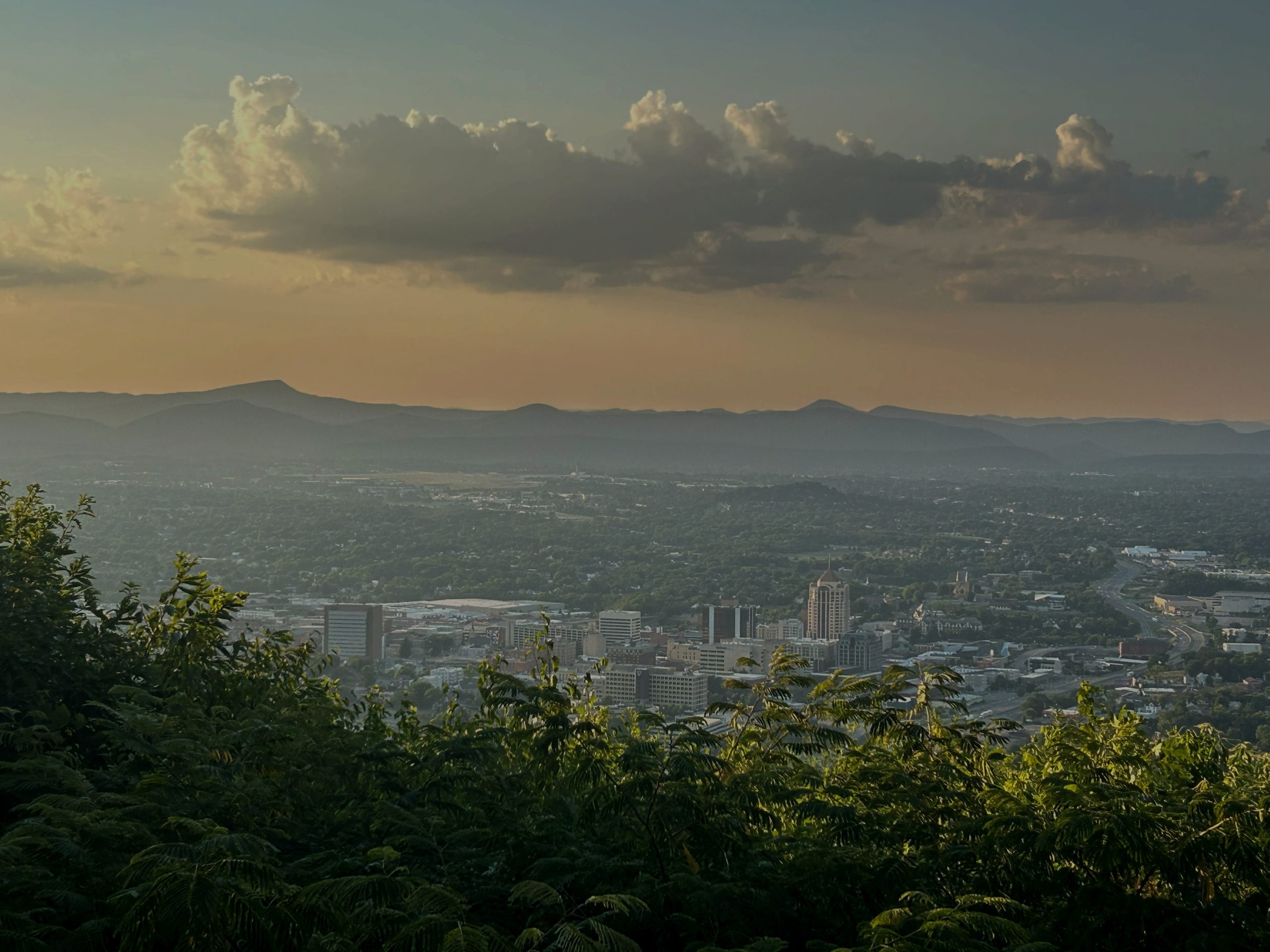
7th District: The ‘lobster district’ looks rural on the map, but is mostly Northern Virginia at the ballot box

Incumbent: John McGuire (R)
That incumbency will do McGuire no good. He’s just an afterthought to drawing a Democratic district that is now drawing multiple candidates, including Del. Dan Helmer of Fairfax County and former Jack Smith deputy J.P. Cooney of Arlington County.
The key thing to know about “the lobster district” is that, despite its looks, it’s a Northern Virginia district — 34.20% of the voting age population is in Fairfax County, 19.68% in Arlington County. Throw in Falls Church and a smidge of Prince William County, and 58.86% of the voting-age population is in the tail of the lobster in Northern Virginia. This is a case where, politically, the tail wags the lobster.
If you look at a color-coded map, the lobster looks red due to all the rural territory, but it’s really blue, politically speaking. This is a +8.3 Democratic district.
8th District: Beyer loses a lot of Northern Virginia and picks up Chesapeake Bay counties

Incumbent: Don Beyer (D)
Here’s a textbook example of how gerrymandering works. The current 8th is a compact district that’s 100% within Northern Virginia. The new district stretches south to York County; now, only 59.05% of the district is in Northern Virginia. It pairs two incumbents, Democrat Don Beyer and Republican Rob Wittman, but in a district designed to benefit a Democrat.
However, it may not be designed to help Beyer, at least not in a nomination fight. He had to fend off primary challengers anyway, who felt he was either too old or not liberal enough; now he loses much of his base. On the other hand, that might help him, because he’s also losing more liberal parts of his district, but he now has to introduce himself to a lot of new voters.

Outside of Northern Virginia, the biggest localities are York County (8.62%) and Gloucester County (5.06%). Throw in part of James City County, and 14.97% of the voting age population is on the Peninsula.
Whoever wins a Democratic primary is safe: This is rated as an 18.0 Democratic district.
9th District: This Southwest Virginia district loses Blacksburg, Radford but expands into Shenandoah Valley

Incumbent: Morgan Griffith (R)
This is the one district Democrats are conceding — and making more Republican. They’re taking out Radford and Blacksburg and adding in a lot of the Shenandoah Valley. Griffith won reelection by 45.16 percentage points; this is now rated a +49.5 Republican.
The shifts here are more subtle: The biggest part of the 9th is now Montgomery County (11.51% of the district). In the new district, it would be Franklin County (6.95%). That means the most populous locality in a Southwest Virginia district would be east of the Blue Ridge, a further sign of the loss of influence of Southwest Virginia.
10th District: Loudoun County still dominates this district, but now it goes into Shenandoah Valley

Incumbent: Suhas Subramanyam (D)
The 10th now runs from Loudoun County south to Rappahannock County. The proposed 10th would run from western Fairfax County west into the northern Shenandoah Valley.
Either way, Loudoun is the anchor — 54.29% before, 52.07% in the new district.
Subramanyam won by 4.55 percentage points in 2024; now this district is rated +12.8 Democratic, so this is a case of redistricting making a Democrat seat safer.
11th District: This district loses its Fairfax dominance but gains other parts of Northern Virginia (and some Shenandoah Valley)

Incumbent: James Walkinshaw (D)
This district doesn’t have a catchy name like the “lobster district,” but it’s a dramatic redrawing nonetheless. Walkinshaw loses most of his constituents.
Fairfax County accounts for 96.74% of the current 11th, Fairfax city the rest. In the proposed 11th, Fairfax County drops down to 49.94%. With Fairfax city, Manassas, Manassas Park and a wedge of Prince William County, this is still very much a Northern Virginia district — 76.55%.
The rest is where a lot of Republican voters in the Shenandoah Valley get “buried.”
Two years ago, this was a +33.82 Democratic district. Now, by absorbing those rural areas, it’s rated a +13.8 Democratic district.
If you’re counting, we currently have four districts dominated by Northern Virginia; the new map would take that to five.
Want more politics and analysis? Sign up for West of the Capital, our weekly political newsletter that goes out on Fridays. Sign up here: