

Want to be the first to see weather news? Sign up for our weekly email weather newsletter, featuring weather journalist Kevin Myatt.
The phrases “locally heavy rain” or “localized flooding” mean that, for most of us, “locally” and “localized” will be somewhere else other than locally where we happen to be located.
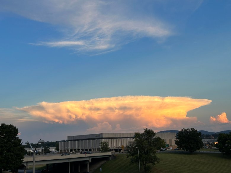
But this past Saturday, the heaviest dot of rainfall in all of Southwest and Southside Virginia just happened to be where 65,000 fans were gathering for a college football game between host Virginia Tech and the visiting Purdue Boilermakers.

While it was a “dot” only a few miles across where 3 to 5 inches of rain fell in part of Blacksburg mostly inside of two hours, it was also more than just rain. Frequent cloud-to-ground lightning crashed around people who left the stadium after the second weather delay, a game stoppage that would last 5 ½ hours and result in most of the game being played after a 6:15 p.m. restart, with Purdue finally winning 24-17. Hail banged so hard against the jumbo scoreboard that it was damaged, according to an official storm report turned into the National Weather Service.

(DISCLOSURE: I am employed full time by Virginia Tech in communications for the Virginia-Maryland College of Veterinary Medicine. Therefore, I won’t be discussing any Virginia Tech policy here. I’ll stick to weather, which is what I promised to do in my first Cardinal Weather column last October.)
Prior to Saturday, the most intense moment in Hokies football weather lore was a late August night in 2000, when an intense and isolated thunderstorm rolled southeast off the mountains minutes before a highly anticipated and nationally televised home kickoff against Georgia Tech, when Virginia Tech was coming off a national title game appearance but wasn’t yet in the ACC. Lightning zigzagged out of the sky and famously fried ESPN analyst Lee Corso’s rental car, sheets of rain blew into the stadium, and, though the teams lined up for the kickoff, that game never got played.
Sept. 9, 2023, has displaced Aug. 27, 2000, in intensity if not in legendary results. People who had been at Lane Stadium on both dates were quick to tell me on social media that Saturday was clearly the worse of the two storms. The numbers back them up.
It was almost certainly the rainiest Virginia Tech home football game day on record. It was the third rainiest day on record for Blacksburg at any time of year going all the way back to 1893.

Saturday’s 4.42 inches in the official National Weather Service gauge less than 2 miles from Lane Stadium came up just .06 inch short of the record 4.48 inches on August 14, 1940. That deluge came from the remnants of the “1940 South Carolina hurricane” that sent the New River at Radford to by far its highest flood on record, at 35.96 feet, more than 10 feet above the second-place flood in 1977. (The New River gauge barely moved this time – localized torrents can’t do what basin-wide tropical downpours can.)
August 14, 1940, also was not a Virginia Tech football game day – the VPI Fighting Gobblers opened that season more than a month later with a 34-12 win on Sept. 21 over Catawba College at Miles Stadium. That was an unseasonably hot day in Blacksburg, reaching 88 degrees (the day after a searing 93), but no rain, hail or lightning.
Saturday came up .02 short of the 4.44 that fell just two years ago on Sept. 22, 2021, from a system partly infused with remnants of Hurricane Nicholas in the middle of a week between a road game at West Virginia and a home game with Richmond.
By logic, then, being the third rainiest day in Blacksburg history, with the two days above it not football game days, and the period of record going back to 1893, Saturday had to be the rainiest Virginia Tech home football game day in history – unless the St. Albans game of Oct. 21, 1892, the lone home game in Tech’s first year of football, just happened to be rainier.
Readers on social media asked me about comparisons with several previous rainy Virginia Tech home game days.
· Oct. 28, 2017, a 24-3 win over Duke through a second-half downpour: 2.23 inches.
· Sept. 26, 2009, a 31-7 blitz of Miami on a soggy day in the 50s: 1.69 inches.
· Oct. 25, 2007, Matt Ryan’s late TD pass in cold rain as Boston College beat Tech 14-10: 2.17 inches.
· Sept. 18, 2003, a 35-19 win over Texas A&M on the breezy outskirts of Hurricane Isabel: 1.05 inches.
· Aug. 27, 2000, Georgia Tech game canceled by thunderstorm: 1.96 inches.
· Oct. 1, 1977, Clemson beats Tech 31-13 in the mud: 1.92 inches. (Thanks to North Carolina Sandhills weather “hound” Chick Jacobs, a Clemson alum, for bringing this to my attention and sending me the link to a great photo on Twitter/X.)
While many Eastern U.S. games experienced weather delays on Saturday – Notre Dame at North Carolina State, Vanderbilt at Wake Forest, James Madison at Virginia (with arguably game-changing negative results for the Cavaliers), and even the Brewers at Yankees baseball game in New York (this video of water flowing in the Yankee Stadium might look familiar to Tech fans) – Blacksburg was particularly unlucky with local atmospheric dynamics.
We knew that an area of rain and storms would be lifting northward out of the Carolinas along a wagging stationary front on Saturday afternoon, with the potential for some locally heavy downpours, prompting a flash flood watch for much of western Virginia. This band of storms is what put the games at Wake Forest and N.C. State on hold as it lifted north. (Later, this was the last round of heavy rain in Blacksburg about 3 p.m., and the brief but electric storms that moved through Charlottesville late in that game.)

It appeared as late as mid-morning on Saturday that the Virginia Tech-Purdue and JMU-UVa games might be able to play at least into the second half and quite possibly get finished before this rain arrived.
But there was also the threat of pop-up cells developing in the sticky warmth ahead of the main band of rain, and there was really no way to tell exactly where those would develop. About 11 a.m., one of the first popped up west of Christiansburg, moving directly north toward Blacksburg.

The first cell, with a few bolts of lightning, was the reason the game was delayed in pre-game, the kickoff moved 15 minutes later to 12:15. But that cell mostly dissipated passing over Blacksburg, and for a minute, it looked like that might be it for a while. But another cell quickly developed exactly where the old one had, and soon, a north-south line of heavy rain cells with some lightning had formed northward toward Blacksburg.
A subtle atmospheric boundary had parked itself right over Blacksburg, possibly outflow from the previous day’s storms to the west, maybe even something left over from similar severe storms with torrential downpours and hail that had occurred two days prior over almost exactly the same location (and I was in the middle of, leaving my daily work at Tech).
It’s always difficult to pick up on exactly where these boundaries are, but in this case, lift and moisture convergence were focused perfectly to rapidly intensify the storm over Lane Stadium, causing it to pour, blow, chunk ice and spark at Hokies and Boilermakers.

Meanwhile, most of the Roanoke Valley, less than an hour’s drive east, got less than a quarter-inch of rainfall, and Liberty University’s home game with New Mexico State kicked off fine on Saturday evening with Lynchburg having only gotten a measly .01 – 1/100 of an inch, or 1/442 what was measured at Blacksburg – of rain. (But Lynchburg residents would be quick to remind us all that they got their flooding downpours in July.) It barely rained at all at Newport, 9 miles northwest of Blacksburg, one Hokies fan observed, and Pearisburg in nearby Giles County to the west got less than half an inch.
Thankfully, most blessedly, there apparently were no fatalities or serious injuries directly related to weather in Blacksburg, though there were flooded roads, blown-over tents and lots of soaked football fans with frayed nerves.

The Hokies game was not the only major outdoor event in Cardinal News territory heavily affected by thunderstorms over the weekend. The Blue Ridge Rock Festival at Virginia International Raceway in Halifax County was interrupted on Thursday night by severe storms, then called off entirely for Saturday and Sunday – resulting in an impromptu parking lot performance by sudden sensation Oliver Anthony.
Extreme weather striking large gatherings is a cold sweat nightmare for weather forecasters and emergency managers.
Just last week, heavy downpours in the desert stranded thousands at the Burning Man festival in Nevada. The Indianapolis 500 had a close call with tornadoes in 2004 and Churchill Downs, where the Kentucky Derby is run, was actually hit by one in June 2011. Timed differently a month earlier or another time when people were watching races, that could have been disastrous.
In 2008, a tornado struck the Georgia Dome while the SEC men’s basketball tournament was ongoing, swaying the overhead scoreboard and ripping a hole in the roof. A game going into overtime may have saved lives, as fans weren’t turned loose on the streets when it hit.
During my Arkansas weather-geek childhood, I remember two scary near-misses affecting events elsewhere in the state.
In November 1983, a college football game in Little Rock between SMU (now soon to be in the ACC) and Arkansas continued right through a tornado warning, cloud-to-ground lightning and a 2-inch deluge that swamped the field. Back then, college football games mostly played through storms rather than delay for lightning or flooding – or a possible tornado.
In December 1987, an EF-3 tornado deposited debris on the parking lot of a crowded dog-racing track in West Memphis, Arkansas. It killed six people, but might have killed hundreds or even thousands with a direct strike on the dog track.
While extreme weather affecting large events has been a problem for decades, climatologists warn there are some reasons to be more concerned in the 21st century.
Neither climate science nor modern weather forecasting can pinpoint where a 4-inch downpour less than 5 miles wide will happen, but a record-warm global climate with hotter oceans is providing more fuel for localized downpours, and higher amounts of precipitable water are being observed in the atmosphere at farther north latitudes in what have been cooler months.
While Virginia pretty much got a pass on sizzling temperatures that broiled many other parts of the U.S. to our west this summer, we did see some localized but extreme downpours, at Lynchburg in July, in Patrick County last month, and this past weekend at Blacksburg – all while much of the Shenandoah Valley and Northern Virginia remain in dire drought.
Blacksburg’s rainiest day happened more than 80 years ago, but six of its 10 rainiest days have occurred since 2000. Five of those 10 rainiest days have happened in September.
Keep bringing those ponchos, and maybe an inflatable raft, to those early-season games in Blacksburg.
Weather ahead
The remainder of this week starts to feel more like fall, especially in the morning, as cooler air from Canada settles southward. Lows will drop into the 40s to lower 50s Friday and Saturday mornings. Afternoons will still be a bit warm, mid 70s to lower 80s mostly, but much less humid. No rain is expected in our region until perhaps some showers with the next cold front on Sunday.
Hurricane Lee will move northward off the East Coast, stirring up some big waves along the shore as it does, so beware of that if you are visiting a coastal area. The storm is expected to move into Nova Scotia by the weekend. Its winds will weaken but the storm will broaden in size, and may affect the Massachusetts, New Hampshire and Maine shorelines with some gusto. Its counterclockwise circulation will help pull cooler, drier air into Virginia.
Long-term patterns suggest a return to warmer than normal temperatures over the next couple of weeks.
In the next few weeks, I hope to provide a summer recap, a new “Focus On” deep-dive segment on factors affecting weather at a specific regional locale (Danville was the first such location profiled in May) and take a deeper look at the fall and winter ahead – all while juggling whatever the weather pattern throws at us week to week.
Journalist Kevin Myatt has been writing about weather for 20 years. His weekly column is sponsored by Oakey’s, a family-run, locally-owned funeral home with locations throughout the Roanoke Valley.
