

Want to be the first to see weather news? Sign up for our weekly email weather newsletter, featuring weather journalist Kevin Myatt.
Hurricane season began June 1, although most years, it is the start of August when we really start paying attention here in Virginia.
For Virginians in the Hampton Roads area, the Eastern Shore and near Chesapeake Bay, the top concern of hurricane season is, well, hurricanes. Those areas of our commonwealth are most prone to experiencing direct hurricane effects, including sustained winds over 74 mph and ocean surges. People living there will become our guests and neighbors by the thousands if evacuations are ordered in advance of a potential hurricane strike. Hopefully that will not be needed at any point in the season ahead.
But farther west in Cardinal News territory – everything in front of the chest and under the beak of the cardinal in our logo, roughly west of Interstate 85 to the southwest tip of the state and north to about Interstate 64 – the historic concern is more about weakening but still potent tropical storms that used to be hurricanes, or even days-old hurricane remnants that barely resemble the original storm, rather than a full-fledged hurricane (though that’s at least possible, see No. 4 below).
Focusing more on our coverage area than our friends to the east or whatever out-of-state coastal areas we like to frequent, here are seven things to keep in mind about hurricane season for Southwest and Southside Virginia.
1. Most of the time, it’s about flooding.
Inland remnants of hurricanes in our region are capable of damaging wind and tornadoes. But, by far, proven repeatedly in our history, the most impactful and deadly aspect of tropical weather for Southwest and Southside Virginia is flooding.
Extremely high dew points, commonly into the 70s (65-70 is considered a pretty sticky summer day), swept in by tropical systems signal lots of energetic water vapor in the air that can be condensed into extremely heavy rainfall by any amount of atmospheric lift, instability and terrain effects. Often, in our region, tropical moisture is overrunning a much cooler air mass and/or bumping against a stalled front, getting lifted and squeezed out efficiently.
We won’t recount here all the examples of extreme flooding related to tropical systems that have occurred in our region, because many of them are recalled in the other numbered points below. But it’s always worthwhile to remember that when we are talking about a tropical system or its remnants moving into our region, it is flooding that is almost always the foremost concern.

2. Atlantic coast is closer, but Gulf of Mexico storms can be worse for us.
The most epic weather disaster in Virginia history happened in August 1969 when remnants of Hurricane Camille, a stalled front and terrain effects combined to dump 1-3 feet of rain on Nelson County and adjacent portions of neighboring counties in less than 12 hours. Entire mountainsides slid off and tiny drainages became raging torrents, killing 153.

The three biggest floods on the James River at Holcomb Rock, near Lynchburg, were in November 1985 from remnants of Hurricane Juan, 1969 from Camille, and 1972 from Hurricane Agnes, in that order. The two biggest floods on the Roanoke River at Roanoke were from Juan and Agnes, respectively. The highest crest on the Dan River at Danville since the current gauge came online in the mid-1990s was from remnants of Hurricane Michael in 2018.
Virginia’s most intense tornado outbreak – at any time, not just related to tropical systems – happened in September 2004, with 38 confirmed tornadoes across the state, from the remnants of Hurricane Ivan.
What all these storms have in common – Camille, Agnes, Juan, Ivan and Michael – is that they each made landfall on the Gulf Coast, not on the Atlantic coast much nearer us.

To be clear, we have experienced many substantial impacts from hurricanes coming ashore on the Atlantic coast, such as Hazel in 1954, David in 1979, Hugo in 1989, Fran in 1996, Frances and Jeanne in 2004 (they made landfall at the same spot three weeks apart on Florida’s east coast), and Florence in 2018, to name a few.
Hurricane Isabel in September 2003, which came ashore over North Carolina’s Outer Banks, had the most widespread damaging impact of any tropical system in Virginia’s recorded weather history with its northwest slide across the state. Southwest areas from Roanoke westward were least affected – Virginia Tech and Texas A&M played football as scheduled on that Thursday night in Blacksburg through a breezy rain.
But, just as often, the worst impacts of Atlantic hurricanes slide east of our region, or barely scrape some counties in Southside. Gulf systems take longer to get here, but we often end up east and northeast of the old circulation center with tornado-spawning shear and/or a band of heavy rain pulling away from the former storm center. Add a stalling front, as with Camille and Juan, or an abnormally deep eastern U.S. trough, as with Agnes, and it compounds the potential for intense and/or prolonged heavy rain.
Anytime a hurricane is hitting somewhere between New Orleans and Tampa, our region should be on the lookout for significant impacts one to three days later – not always, but often.

3. Dry air being pulled into tropical circulations can spin up more tornadoes.
When Hurricane Ivan was nearing the Gulf Coast of Alabama and the western Florida Panhandle in September 2004, its eye structure began disintegrating as it came ashore.
That meant a blessedly weaker hurricane landfall two levels below the Category 5 intensity it once had, but it also signaled the storm was ingesting dry air, and that would have profound impacts for Virginia a couple of days later.
Similarly, Hurricane Florence brought weaker-than-expected rainfall to our region as it made its way north and west from an eastern North Carolina landfall in 2018, but the sun popped out over central Virginia as it pulled drier air east of its old circulation center, and the Richmond metro area experienced a tornado outbreak that killed one person.
Dry air entrained into an inland tropical system creates atmospheric boundaries upon which shearing winds can focus tight rotation, and also, sometimes, narrow zones of sun-warmed air that increase instability. (See last week’s post on thunderstorms for discussion of the importance of shear and instability in the development of rotating storms.) This can lead to greater tornado production than a system that maintains a more solid rain shield, though embedded, rain-wrapped circulations sometimes occur in those also.
Much of the pre-Ivan communication for Virginia focused on flooding, coming as it did two weeks after Frances had dumped 4-8 inches of rain. But rainfall amounts ended up being much less, around 1-2 inches in squally showers for most, and tornadoes became its lasting legacy in the Old Dominion. So, it’s not quite always about flooding.

4. Hurricane-force winds are at least remotely possible, but tropical storm force is bad enough.
It is at least theoretically possible for a fast-moving, intense hurricane hitting the coast of the Carolinas, under some atmospheric conditions, to retain hurricane-force winds (74 mph or greater sustained – not just gusts) reaching our region, especially more toward Southside closer to the coast, or with somewhat higher-level winds hitting the mountains. Hazel in 1954 and Hugo in 1989 came close to doing this.
(A Category 3 or stronger hurricane moving due west rapidly from the Hampton Roads region of Virginia could most easily accomplish this, but that is an extremely unlikely and unspeakably horrible scenario to ponder.)
Our region has lots of deciduous and evergreen trees that are not as flexible to wind as coastal varieties like palm trees. Also, over time, our trees become naturally braced against much more common westerly wind vectors, common behind cold fronts or in front of squall lines, rather than from other directions, which often occur with the counterclockwise circulation of tropical systems tracking into our region. So, easterly winds of similar strength to westerly gusts can do comparatively more damage to trees, some of which end up on power lines, across roads or on houses.
Tropical storm force winds of 39 to 73 mph sustained, or even tropical depression winds of up to 38 mph with sometimes stronger gusts, are plenty strong enough to knock some trees down (especially in wet ground), crash limbs into power lines and knock out power for thousands.
We don’t have to look back far for an example. Just last fall, the much-weakened circulation center of once-Hurricane Ian spun up easterly winds gusting 40-50 mph in areas east of the Blue Ridge, knocking out power to 100,000, and killing one person in Campbell County when a tree fell on a vehicle.

5. Hot water fuels hurricanes, but it takes more than just hot water to make one.
The big concern this particular hurricane season is the widespread extremely warm sea surface temperatures, relative to historic norms, that are being observed over much of the Atlantic Ocean.
Nothing similar to this has been seen in the Atlantic at the same time as an El Niño, a narrow stream of warm sea surface temperatures in the Pacific near the equator. El Niño typically produces strong upper-level winds that shear apart many would-be tropical cyclones in the Atlantic basin, reducing the number of tropical cyclones during hurricane season.
Transient atmospheric and oceanic patterns, climate change from greenhouse gases emitted by human industry and the mandated reduction of sun-blocking sulfur particles in ship exhaust over the last few years have all been considered as contributors to the extra-warm Atlantic.
The warm water provides extra fuel for any would-be tropical systems, but atmospheric patterns must also be conducive for a swirl over the ocean to mature into a tropical storm or hurricane – namely, stable high pressure high in the atmosphere, to vent the storm and allow the eye wall to build and not be sheared off.
Being in somewhat uncharted water, quite literally, this Atlantic hurricane season is a bit of an observational experimental case to see what happens with seemingly conflicting factors. Forecasts have bounced upward slightly for the number of expected tropical systems compared to what is normally expected in an El Niño season in the Atlantic. But if conditions do line up for hurricane development even in short windows, there may be some really nasty ones – and the greater chance our region could be affected by one.

6. Hurricanes help autumn happen.
It might not be politically correct – and can seem downright insensitive – to suggest anything positive about hurricanes.
But it’s true that hurricanes, energized by warm ocean waters, expend that heat through wind and rain and transfer heat from tropical regions to more northern latitudes, dislodging cooler air masses southward, helping autumn happen.
Typhoons (hurricanes by another name) in the western Pacific sometimes help trigger the move of colder air masses from the Arctic region southward over North America. More obviously observable to us, it’s not uncommon as we get toward October and November for a hurricane passing along or east of the U.S. East Coast to pull down colder air from Canada with its counterclockwise circulation. We can have some of our most spectacular clear, crisp autumn weather in the wake of a hurricane that missed or scraped our region to the east.
Hurricane Wilma’s passage to our east in 2005 brought on October snow squalls in eastern West Virginia. Last fall, Hurricane Ian’s remnants brought some early October sleet and snow showers to the mile-high-plus country of western North Carolina and the Mount Rogers/Grayson Highlands area of Virginia. (Hurricane/Superstorm Sandy is sort of a special case on this topic, with its odd hybrid nature and sharp westward turn, but it did bring heavy snow to West Virginia and lighter snow to western Virginia in late October 2012).
Autumn happens with or without a lot of tropical systems, but they can and often do help it along.
7. The man leading hurricane forecasting is one of our own.

We often refer to forecasters in federal offices collectively as a distant “they,” as in “They are saying we are going to get 5 inches of rain from that hurricane.” But the new leader of the National Hurricane Center is one of “us.”
Mike Brennan, born and reared in the Roanoke Valley, a former intern at WDBJ (Channel 7) where longtime meteorologist Robin Reed was his mentor, and a former student at Cave Spring High School and Virginia Western Community College, was named director of the National Hurricane Center earlier this year. This is one of the most high-profile jobs in weather nationally, often appearing on television networks as serious storms approach our coasts. From humble beginnings, and memories of his grandmother being flooded out at Salem Village during the Flood of 1985 in the Roanoke Valley from Hurricane Juan’s remnants, he has steadily worked his way toward this lofty position over the last three decades.
”Mike Brennan is amazing,” said Ken Graham, director of the National Weather Service and Brennan’s predecessor as director of the National Hurricane Center. “I worked with him the entire four years that I was at the hurricane center, and he was the chief hurricane specialist. So, actually he ran all the operations for the National Hurricane Center. He’s got tons of operational experience. I am fully confident in Mike, he’s such a great scientist, but not just that, he’s a great communicator.
“He sure understands this area,” Graham said, talking in the National Weather Service office at Blacksburg. And, with a smile, “He’s going to do a lot better than that last guy.”
Lynchburg’s record rainfall
It wasn’t related to a tropical system at all, but Lynchburg set a record for its wettest July on record, with 10.39 inches of rain, edging out July 1984 by 0.09.
Two of Lynchburg’s four wettest Julys in 130 years of weather data have now happened in back-to-back years, as July 2022 ranks fourth with 9.47 inches. July 1916, with 9.76 inches, is in third place.
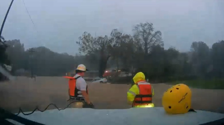
Nearly 80% of that rainfall for this most recent July occurred in just four consecutive days, July 13-16, when 8.14 inches of rain fell as a series of training thunderstorms moved over Lynchburg and nearby areas. Some locations got up to 12 inches, with creeks rising out of their banks and several swift-water rescues.
July was dramatically different in rainfall just 70 miles down U.S. 29. Danville only got 2.61 inches of rain for the month, more than 2 inches below normal and its 14th driest July in 107 years of weather records.
To the west, Roanoke got 5.60 inches of rain in July, more than an inch above normal, while Blacksburg received. 4.38 inches, very close to normal (0.17 above). Results are similarly variable throughout our region – it’s not possible to characterize July as a “wet” or “dry” month across the entirety of Cardinal News territory.
Roanoke and Danville had their wettest Julys just a decade ago in 2013, Roanoke getting almost 13 inches, 12.73, and Danville nearly a foot, 11.50. That was a month with more widespread, longer-lasting periods of rain than we saw in this most recent July, but also one punctuated by extremely heavy localized downpours. Blacksburg recorded its wettest July long ago, in 1905, with 12.05 inches.
We’ll soon see if tropical systems and typical subtropical flow across the South from El Niño bring on more soaking months for more of our area in 2023.
Journalist Kevin Myatt has been writing about weather for 19 years. His weekly column is sponsored by Oakey’s, a family-run, locally-owned funeral home with locations throughout the Roanoke Valley.

