Want to be the first to see weather news? Sign up for our weekly email weather newsletter, featuring weather journalist Kevin Myatt.
UPDATED, April 1, 7:56 p.m.:
Gusty westerly to northwesterly winds sometimes topping 50 mph will continue until near midnight along and west of the Blue Ridge, with occasional wind gusts above 40 mph in lower elevations east of the Blue Ridge, then only slowly diminish into Sunday morning.
Statement from Appalachian Power
Appalachian Power has issued the following:
Storm Response Efforts
- Appalachian Power planned for significant outages from this storm, and has more than 1,600 workers dedicated to restoring electric service. This includes more than 900 line workers, 120 damage assessors and 450 tree removal workers.
- In advance of the storm the company secured more than 200 line workers from outside the company’s service area that are traveling from as far away as Texas and Louisiana to assist with restoration.
- More than 100 additional call center employees are working to take customer calls about outages.
- Appalachian Power’s storm response team is assessing damage and making repairs on large known outages where it is safe to do so.
Restoration Estimates
- We will not be able to provide accurate restoration estimates until the weather threat passes and damage assessors are able to determine the extent of damage to electrical facilities.
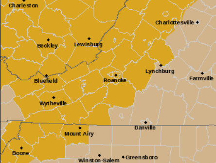
As of 7:15 p.m., more than 57,000 utility customers in Virginia had lost power, most of them within Southwest and Southside Virginia areas covered by Cardinal News. The Interstate 81 corridor has been hardest hit, with 1,000 or more customers without power in each of the counties along its path from Botetourt County southwest to Washington County.
Montgomery and Washington counties along I-81 each had more than 3,000 customers without power, while Pulaski had almost 3,000, and Roanoke, Wythe and Smyth counties between 1,000 and 2,000 each. Other localities outside the I-81 corridor hard-hit with power outages include more than 3,000 in Scott County and more than 2,000 in Amherst County, according to a compilation of utility reports on poweroutages.us.
Many trees have been reported blown down across the area, including one blocking an exit ramp of U.S. 220 at Ridgeway in Henry County for a while. Power lines have been downed and transformers blown in various areas, causing power outages and occasionally small brush fires.
Roof damage occurred at a business in Vinton in Roanoke County, and shingles were reported blown off a building in Rocky Mount, likely one of many in the region to which this has occurred.
The winds are the result of a cold front being propelled through the region by a strong low-pressure system tracking west and north of our region. The same weather system resulted in more than 215 tornado warnings Friday into early Saturday for states west of us, with at least 21 killed in tornadoes. There was also heavy snow in the Upper Midwest and more severe storms today in the Northeast.
End of update.
* * *
April will roar in like a lion with gusty winds that are no joke on Saturday.
Much of the western side of Virginia, generally near and west of the Blue Ridge, is under a high wind warning Saturday, with wind advisories covering most of the rest of the commonwealth.
Gusts over 40 mph may occur anywhere in Virginia, while the best chance of gusts topping 50 mph, perhaps 60 mph in some cases, will be near and west of the mountains, which break the wind flow into waves much like water hitting against a ledge.
Winds of this velocity will be sufficient to break some tree limbs and push over some weaker trees, with limbs on power lines and perhaps some power lines taken down directly by wind in a few places leading to scattered to numerous power outages, especially on the western side of the state.
It would be advisable to keep cellphones and computer laptops charged up in case the power goes out at your location. Sunday morning will not be frigid like after high winds just before Christmas, but lows in the 30s to lower 40s may still require alternate heating sources (or a lot of blankets) for a while until power can be restored.
The high winds will follow a strong cold front pushing eastward, already triggering several reports of tornadoes in the central U.S. from Arkansas to Iowa on this Friday afternoon and early evening, with more tornadoes and severe storms with hail and high winds continuing into the evening and overnight.
These thunderstorms will mostly weaken before reaching Virginia, with some breezy morning showers with a random rumble of thunder about all we’ll likely see. The southwest tip of Virginia was in a “marginal” risk of severe storms, issued by the Storm Prediction Center, which means perhaps a stronger gust or two could linger in overnight storms that reach that area.
Somewhat cooler, more stable air along and east of the Appalachians, weak moisture flow into our region and the best upper-level lift being carried with low-pressure toward the Great Lakes and Northeast will keep Southwest and Southside Virginia mostly out of the severe storms risk this go-round, but that will not deter the gusty winds that will commence as a cold front moves west to east during the day.
This front is “strong” for its wind dynamics, not for the depth of its cold air, which is of Pacific origin, not Arctic, like we saw just before Christmas. In fact, the combination of sunshine coming back out after morning showers and downsloping compression of the winds blowing down the Appalachian slopes will cause a Saturday afternoon spike of temperatures into the 70s behind the “cold” front across much of our region. The somewhat colder air won’t settle in until overnight and early Sunday.
Winds will likely peak during the afternoon and early evening hours, then gradually diminish overnight. Although Sunday and Monday mornings will be a bit chilly, with even some scattered near-freezing temperatures possible in outlying areas west of the Blue Ridge, the week ahead will get progressively warmer and stay dry until another chance of showers at midweek.
Journalist Kevin Myatt has been writing about weather for 19 years. His weekly column is sponsored by Oakey’s, a family-run, locally-owned funeral home with locations throughout the Roanoke Valley.