

Want to be the first to see weather news? Sign up for our weekly email weather newsletter, featuring weather journalist Kevin Myatt.
Snowfall is a terrible place to start if you’re seeking to find patterns or trends in regional climate.
Rather than skiing smooth slopes, snowfall totals bounce up and down maniacally season to season. They can vary widely across our region in the same season and are sometimes difficult to discern bumping over potholes of missing data.
At the end of this column, you will find instructions about to how to enter the first Cardinal Weather snowfall prediction contest, in which you can guess the total snowfall and first 1-inch snowfall date (between Dec. 1 and March 31, excluding any premature November stuff that might happen) for two sites of your choice among six in and near Southwest and Southside Virginia. This is a slight revision of a contest I ran for 13 of the last 14 years in my previous weather column for The Roanoke Times.
To get us in the snowfall contest mood, we are currently in a decidedly cold pattern lasting into next week, but after a Tuesday morning flirtation with a little ice in higher elevations, it looks mostly dry. More on this in the “Looking Ahead” portion of the column.
To provide some field markers for those who may not be familiar with all the numbers, I looked over historical snowfall data for six top-level climate stations the National Weather Service oversees in and near our region. You will find that list at the very end of this column, following the contest explanation.
Missing data is perhaps the most frustrating element of regional snowfall records.
The 1959-60 winter is widely the most extremely snowy across our region, as I detailed in a February 2020 article for The Washington Post’s Capital Weather Gang. But right smack in the middle of it, Blacksburg has no data for the entire month of February, leaving a dozen other winters above it when almost certainly it should be first or second with something north of 65 inches.
The official database shows no snowfall for Danville in 1995-96. That was one of the most epic winters on record across our region. Richmond topped 30 inches and Raleigh had 17, with Roanoke and Lynchburg over 50 inches. Danville wasn’t a doughnut hole in the middle of all that.
No snowfall in Bluefield, W.Va., in 2001-02 or 2002-03? Well of course that didn’t happen. 2002-03 was a widely pretty snowy winter across our region, and it snows at least an inch or two in Bluefield just about every time the wind turns to the northwest, as it does in some of the adjacent areas of far Southwest Virginia. But there are 271 days of missing weather data at Bluefield from 2001 to 2003, many in winter.
My listing of historic averages and extremes at the end of this column does its best to eliminate winter totals that are obviously hobbled by missing data, but I’m sure it’s not perfect. It will give you a good idea of the parameters.
Geographical factors play into snowfall totals, with very generally a decline of average snowfall totals west to east across Cardinal News territory.
The role of elevation in that is obvious. Colder atmospheric layers aloft reach higher elevations first and it can be snowing there when it’s a cold rain a few hundred feet lower. The higher elevations are in our region’s western areas.

Areas west of Interstate 77 and the mountains near the West Virginia line often get bonus snow on northwest upslope wind flow, as moisture largely from the Great Lakes is lifted up and over the mountains, cooling and condensing into snow on northwest winds behind winter cold fronts. This snow helps keep the West Virginia ski industry going.
To a lesser extent, this upslope snow often reaches the New River Valley and Blue Ridge in parallel streaky bands. The Roanoke Valley sometimes gets a rogue ground-whitening snow squall out of upslope patterns, but more often flurries or nothing. The sun is often shining at Lynchburg and Danville during upslope snow episodes.
Cold-air damming patterns, however, tend to lead to colder conditions east of I-77, as high pressure from the northeast presses cold air south bumping against the Appalachians. Sometimes warmer air surges into the far southwest, so it keeps snowing at Roanoke and Lynchburg while Wise County is in the 50s with rain.
And often it’s just the direction storm systems move. Locations to the west and north of storm tracks often get snow while it stays rain to the east and south, with mix in between. This will usually again favor the northern and western parts of our region with more snow than those to the south and east, but there’s that occasional system moving more even more south and east that clocks Southside while leaving the mountains high and dry.
Put all that together and it leads to widely varying annual snowfall totals.
Lynchburg had its first snowless winter in 2019-2020, a decade after getting almost three feet in 2009-10. (The 1996-97 zero in the database a year after getting a record 57 in 1995-96 appears to be errant, but that was still likely a deep dive from a lot to a very little.)
A century before, Roanoke followed up a 44.5-inch snowfall winter in 1917-18 – still its sixth snowiest on record – with back-to-back snowless winters in 1918-19 and 1919-20. The first of those two snowless winters was a very meager winter across much of the Eastern U.S., but the second was just a lucky/unlucky draw for the Star City, depending on how you feel about snow, as all the season’s winter storms missed to the west or east. Then, to end that snow drought, came 20 inches on a single day in January 1921.
Right in the middle of the constantly snowy 1960s and 1970s there is the 1975-76 winter, with 3 inches total at Blacksburg, 2 at Roanoke and Lynchburg, and nothing at Danville.
Broader climatological studies have found that a greater percentage of winter precipitation is falling as liquid instead of frozen across the nation as average winter temperatures edge upward, but in some areas that may be partially offset by a few bigger winter storms juiced by greater moisture flow supplied by warmer oceans.
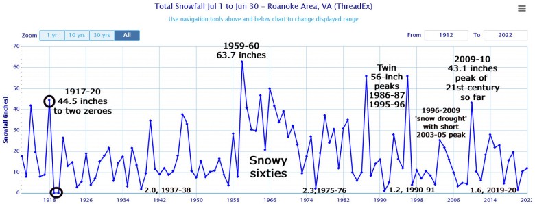
There may be something of a trend toward “fewer but bigger” snowstorms even in our region in the past several years. Roanoke had no snowfalls over 8 inches from the 1996-97 winter through the 2008-09 winter. But since 2009 there have been nine such storms, including four over a foot, yet the 10-year snowfall average has stayed at or below 18 inches after spending 32 years above that line 1960 to 1992.
There don’t seem to be as many small to medium snowfalls to bolster the numbers from a few larger snow events as there once were, but of course, it’s too a small a sample size and too recent thus far to declare that fully.
The extreme, not fully understood snowiness of the 1960s presents a problem for any long-term snowfall comparisons in our region. The 1960s were not just snowier than any decade since in our region, but any decade before.
So, yes, the kids in the 1960s who are senior citizens now got more snow than their kids or grandkids did, but they also got more snow than their parents did.
Truthfully, our region’s winter snowfall totals for any given season usually hinge more on how a handful of potential winter storm setups play out more than they do on long-lasting patterns. As discussed previously, this is what broad seasonal forecasts and focusing on major climate oscillations like La Niña can’t easily discern.
Much like presuming the .350 batter on a baseball team has a better chance of getting on base than the .175 hitter, knowing these patterns can give some idea or probability of certain setups occurring, but sometimes the cleanup batter strikes out while the desperation pinch-hitter smacks a home run.
We can have cold, dry winters with little snow, or mild winters with one or two big snowstorms.
All this is why I’m more apt to call entries in the snowfall prediction contest, and really, predictions of various weather experts and certainly those of my own, “guesses” rather than forecasts.
Even getting a lot of the meteorology right, predicting annual snowfall for particular locations is, at best, only a somewhat educated guess.

Stats of the week
We’ll focus on two rainfall statistics from Friday’s passage of the remnants of Hurricane Nicole. (1) The most rainfall reported to the National Weather Service in Cardinal News territory was 5.02 inches at Glasgow in Rockbridge County, as amounts mostly were within the predicted 1-to-4-inch range across the region. (2) Roanoke’s 2.88 inches was the most recorded on any Nov. 11, going back to the start of local records in 1912, and the most on any calendar day since 3.05 fell on Oct. 7, 2016, associated with Hurricane Matthew.
Looking ahead
One word: COLD. The Arctic air that arrived over the weekend gets reinforced the rest of this week, with upper teens to mid 20s lows and upper 30s to mid 40s highs across our region, comparable to slightly BELOW mid-January normal temperatures. At this point there is no obvious system that would bring a contest-upstaging November widespread snowfall, but sometimes upper-level shortwaves cutting across the South at the rim of the Arctic intrusion can spin up a snow chance seemingly out of thin air in 2 or 3 days. (Recall last Jan. 3 going from “maybe some snow Monday” on Saturday to winter storm warning by Sunday morning!). So I’ll keep an eye out for that. It does look to get a little milder, and possibly rainy, near Thanksgiving.
Enter the snowfall contest
The contest works like this: Each entrant picks the total snowfall rounded to the nearest inch from Dec. 1 to March 31, and the date of the first snowfall of at least 1 inch within that same timeframe, for two climate stations of your choice among six in and near Cardinal News territory.
I always use the weather service’s major climate stations because they are easily verifiable using standardized measurement and, in recent times, dependable reports. Running this contest out of The Roanoke Times in the past, those stations were always Roanoke and Blacksburg. With a larger Cardinal News area of coverage, Lynchburg and Danville are also in the region.
This provides pretty good geographical distribution from the New River Valley to Southside, but largely leaves out Southwest areas west of I-77. To compensate for that, I am adding Tri-Cities Airport, Tennessee, just across the state line from Bristol, and Bluefield, W.Va., barely over the West Virginia state line, to the list of stations you can choose from to project snowfall.
So here is how you enter.
- Email weather@cardinalnews.org with the subject line: “Snowfall contest entry.”
- List your name and general location (city, town or part of a county). More than one person can enter on the same email — encouraged for families. I don’t mind an attached document if there are a large number of entries, such as a school class (strongly encouraged!). There is no age requirement – I love having kids and teens enter.
- Pick two locations among Blacksburg; Bluefield, W.Va.; Danville; Lynchburg; Roanoke and Tri-Cities Airport, Tenn., you want to guess for. I don’t care which two you pick, they don’t have to be the two closest to your location, just pick two.
- Project the total snowfall from Dec. 1 to March 31, rounded to the nearest inch (if you give me a fraction or decimal I will round it myself) for each site. Snow in November or April doesn’t count in this contest.
- Project the date of the first snowfall of at least 1 inch, within that Dec. 1-March 31 timeframe, for each location you choose. (The first date on which there is 1 inch of snow on the ground counts – if there is half an inch before midnight and a half-inch after midnight in the same snowfall, the second of the two dates counts.) Again, snowfall in November doesn’t count.
A sample entry might look like this:
O.M. Winter, Snowville, Pulaski County.
Blacksburg, 47 inches, Dec. 25.
Bluefield, 62 inches, Dec. 10.
That simple.
I am taking entries through Black Friday, Nov. 25, at midnight. I will put out reminders on social media and in the Cardinal newsletters and this column next week.
The winner will be the person who has the lowest number when adding up the missed inches and missed days from their predictions.
The contest is mostly for pride and recognition in this space as the region’s master weather predictor, but I will personally pitch in a $25 gift card for the winner – and possibly some other stuff.
I’ll put my own skin in the game with my predictions next week – except I’m going to pick for all six sites.
In the meantime, to help guide your snowfall guesses, here is a quick listing of the six sites with average snowfall over period of record (85-130 years in all cases) and maximum and minimum snowfall (I didn’t list zero/low-total years that had missing months or obvious missing data), rounded to the nearest inch, for the December-March period (somewhat less than annual snowfall averages in some locations, with no April or November numbers figured in).
Blacksburg: Average 20, maximum 64 (1995-96), minimum 2 (1951-52)
Bluefield: Average 29, maximum 102 (1946-47), minimum 7 (1990-91, 1991-92)
Danville: Average 7, maximum 41 (1947-48), minimum 0 (1975-76)
Lynchburg: Average 14, maximum 57 (1995-96), minimum 0 (2019-20)
Roanoke: Average 17, maximum 63 (1959-60), minimum 0 (1918-19, 1919-20)
Tri-Cities: Average 13, maximum 51 (1959-60), minimum 0 (2001-02)
* * *
I’ve proven worse at forecasting the number of entries than forecasting snowfall over the years. I hope to get at least 100 entries in this first Cardinal Weather snowfall prediction contest. Shock me by sending in 500 and I’ll raise the winning gift card to $50 and give second place something too.
Good luck. It is mostly luck.
Journalist Kevin Myatt has been writing about weather for 19 years. His weekly column is sponsored by Oakey’s, a family-run, locally-owned funeral home with locations throughout the Roanoke Valley.
